Grab Your Umbrella: Heavy Rain and Blustery Winds Set to Sweep Through Wollongong
Wet and Windy Conditions Ahead for the Illawarra
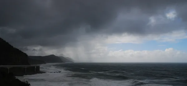
Residents of Wollongong should prepare for a significant shift in weather this Friday, 27 March 2026. The Bureau of Meteorology and local weather stations are predicting a damp and blustery day across the region, as a cold front brings persistent rain and strong westerly winds to the Illawarra coast. If you are heading out, an umbrella and a windbreaker will be essential pieces of gear.
Morning Forecast: A Damp Start
The day is expected to begin under heavy overcast skies. Morning temperatures will hover around 13°C to 15°C, providing a relatively mild but humid start to the day. However, the chance of precipitation is high from the early hours, with a 60% probability of light showers during the morning commute. Coastal mist may reduce visibility on the roads, so motorists are advised to exercise caution, particularly on the M1 and around the Bulli Pass.
Afternoon Outlook: Peak Rainfall and Gusty Winds
As we move into the afternoon, the weather is set to intensify. While the mercury may reach a daily maximum of 19°C, it will likely feel much cooler due to increasing wind speeds. Meteorologists are tracking a 100% probability of rain during this period, with predicted totals between 5mm and 10mm. There is also a moderate risk of isolated thunderstorms developing mid-afternoon, which could bring brief but heavy downpours. The wind will shift to the west, with sustained speeds of 37 km/h and gusts potentially reaching 55 km/h, making outdoor activities challenging.
Evening and Night: The Chill Sets In
By the evening, the heaviest rain is expected to taper off into scattered showers, but the temperature will drop sharply. Nighttime lows are predicted to hit approximately 13°C, though some local models suggest a sharper dip toward the single digits in the late night hours. Winds will remain strong, maintaining gusts of up to 58 km/h through the night, which may cause minor disruptions or move unanchored outdoor furniture.
Summary of Forecast Details
- Temperature Range: Low of 13°C, High of 19°C.
- Rainfall: High probability (80-100%) with 5-10mm expected.
- Wind Warnings: Westerly winds with gusts up to 58 km/h.
- Special Notices: Risk of afternoon thunderstorms and reduced road visibility.
Looking ahead to the weekend, conditions are expected to clear significantly by Saturday morning, bringing a return to sunny skies and calmer conditions for those planning outdoor activities.
Theatre Magic and Local Markets: What's On in Wollongong Today
Friday Footy Fever and School Holiday Bliss: Your Wollongong Morning Briefing
Wollongong Traffic: University Diversions Conclude and Mount Ousley Upgrades Impact Friday Commute