Sunscreen Then Umbrellas: A Volatile Weather Day for the Illawarra
Morning: A Muggy and Sunny Start
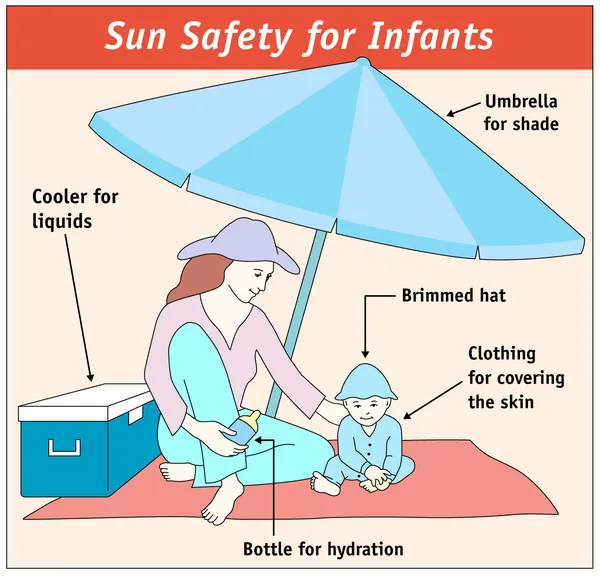
Residents across Wollongong and the Illawarra should prepare for a significant shift in conditions this Thursday, March 26, 2026. The day is set to begin with a mix of sun and clouds, accompanied by a noticeable surge in humidity, which is expected to hover around 81%. Early morning temperatures will start at a mild 19°C, quickly climbing as the sun breaks through the initial cloud cover. Despite the looming storms, the Bureau of Meteorology has advised that sun protection will be necessary for the first half of the day. A high UV Index of 7 is predicted, with the most intense solar radiation occurring between 9:50 am and 4:00 pm. If you are heading out early, light clothing is recommended to handle the morning mugginess.
Afternoon: Storm Clouds Gather
As we transition into the afternoon, the weather is expected to take a dramatic turn. Temperatures will peak at a high of 27°C, but the heat will be short-lived as a low-pressure system moves across the coast. There is a 95% to 100% chance of rainfall, with most of the activity concentrated in the post-midday hours. Meteorologists are tracking the development of thunderstorms that are likely to be severe. These storms bring the potential for heavy downpours, with rainfall totals estimated between 5 mm and 25 mm. Localized flash flooding in low-lying areas and a risk of hail have been noted for the broader region, making the afternoon commute potentially hazardous.
Evening: Rainfall and Wind Warnings
The stormy conditions are expected to persist well into the evening and night. While the mercury will drop back toward 18°C, the intensity of the rain may remain high. Nighttime humidity will stay elevated at 69%, and the chance of rain remains at a steady 65%. Wind conditions, which will start as a light Northwesterly at 6 km/h, may become unpredictable during storm cells. Damaging wind gusts are a possibility, and residents are advised to secure loose outdoor furniture and remain indoors during the peak of the electrical activity. The sky is expected to remain overcast, though some clearing may begin very late into the night as the system moves further out to sea.
Summary of Conditions and Safety Notices
- Temperature Range: A minimum of 19°C and a maximum of 27°C.
- Rainfall: High probability (95%+) with 5 mm to 25 mm expected.
- UV Alert: High index of 7; protection required until 4:00 pm.
- Wind/Storm Hazards: Possible severe thunderstorms with damaging winds and heavy rain leading to potential flash flooding.
Given the high likelihood of afternoon storms, wollongong.news advises all residents to keep an eye on live radar updates and avoid unnecessary travel during heavy downpours. Ensure pets are kept indoors and storm drains around your property are clear of debris.
Theatre Magic and Local Markets: What's On in Wollongong Today
Friday Footy Fever and School Holiday Bliss: Your Wollongong Morning Briefing
Wollongong Traffic: University Diversions Conclude and Mount Ousley Upgrades Impact Friday Commute